Beautiful Feet Geography
One of the first "made for homeschoolers" curriculum that I came across was Beautiful Feet Books. Back in the day (1993 or so), I purchased their CA history study guide. In my second year of homeschooling, just having had a baby, and still not completely sure what in the world we were doing, this study guide helped make our homeschool successful.
A few years later, I purchased a geography study guide from Beautiful Feet Books to use with my now 24 year old daughter. She was a very "hands-on" kid, so I thought creating a map with our study would be perfect for her. And it was!
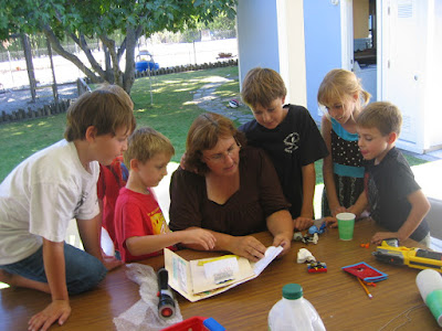
Fast forward to today. I have wanted to use this study guide again for a long time. I also wanted to try it in a group setting. This year I took the plunge and asked two families to join us- making for 9 children between the ages of 7 and 13 years old.

About the study guide:
Using 4 Holling Clancy Holling books- Paddle-to-the-Sea, Minn of the Mississippi, Tree in the Trail, and Seabird- the study guide provides reading assignments (which pages of the book to read), map assignments (what to color and label), research assignments (such as natural resources for a specific region), and additional resource recommendation (s). Each book covers a different geographic region.
Paddle-to-the Sea, the book that we just completed, takes the student from Lake Nipigon (in Canada) above the great lakes through each lake and its surrounding areas starting with Lake Superior traveling to the Atlantic Ocean.
Each lesson assigns a few pages to read from the book, and then gives a map assignment that goes with those pages. This makes a nice connection- we read about a particular place and then immediately color and label that place on the map. Additional little drawings (a canoe, Niagara Falls...) that the students do are placed (glued) on the map.
The students also keep a notebook. For Paddle-to-the-Sea, my students had a few vocabulary words that they put in their "glossary" (pages at the end of their notebooks). They also had information on Canadian Geese, Iron Ore, Copper, and Ballast.


Using this study guide in a group setting did bring some challenges (for me), but I am going to save those for another post. There is nothing wrong with the study guide- I just needed to make a few adjustments from how I would "normally" do school. It was a different setting after all. I will try to do a "part 2" on this after the new year.
You can now order this study guide as a download!
Maps to purchase to use with the study guide.
A few years later, I purchased a geography study guide from Beautiful Feet Books to use with my now 24 year old daughter. She was a very "hands-on" kid, so I thought creating a map with our study would be perfect for her. And it was!
Fast forward to today. I have wanted to use this study guide again for a long time. I also wanted to try it in a group setting. This year I took the plunge and asked two families to join us- making for 9 children between the ages of 7 and 13 years old.

About the study guide:
Using 4 Holling Clancy Holling books- Paddle-to-the-Sea, Minn of the Mississippi, Tree in the Trail, and Seabird- the study guide provides reading assignments (which pages of the book to read), map assignments (what to color and label), research assignments (such as natural resources for a specific region), and additional resource recommendation (s). Each book covers a different geographic region.
Paddle-to-the Sea, the book that we just completed, takes the student from Lake Nipigon (in Canada) above the great lakes through each lake and its surrounding areas starting with Lake Superior traveling to the Atlantic Ocean.
Each lesson assigns a few pages to read from the book, and then gives a map assignment that goes with those pages. This makes a nice connection- we read about a particular place and then immediately color and label that place on the map. Additional little drawings (a canoe, Niagara Falls...) that the students do are placed (glued) on the map.
The students also keep a notebook. For Paddle-to-the-Sea, my students had a few vocabulary words that they put in their "glossary" (pages at the end of their notebooks). They also had information on Canadian Geese, Iron Ore, Copper, and Ballast.


Each book title has 9 or 10 lessons in the study guide. This could easily be completed in a week or two or, as we did, over a 9 or 10 week period doing one lesson a week.

Using this study guide in a group setting did bring some challenges (for me), but I am going to save those for another post. There is nothing wrong with the study guide- I just needed to make a few adjustments from how I would "normally" do school. It was a different setting after all. I will try to do a "part 2" on this after the new year.
You can now order this study guide as a download!
Maps to purchase to use with the study guide.


wow, I love the maps! My oldest would like this, and the Holling books are really good. Thanks for posting this!
ReplyDelete